Winter Weather in the Haut-Saint-Laurent
The entire Montreal area experienced a snow event between Tuesday, March 14, and Wednesday morning. The only question is "How much did we get ?"
It is very difficult to measure snow accurately due to variation in density and effects of wind. The instrument that is used most commonly is a Nipher snow guage.
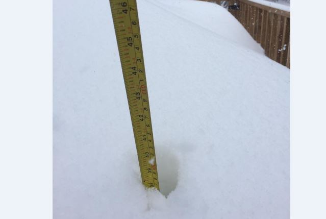
According to this instrument installed at the Ormstown weather atation, we received a total of 74 centimeters or 29 inches of snow which melted to 47 millimiters or 1,9 inch of water.
The normal relationship between snow and water content is 10 to 1. This snow was quite fluffy so the water content was below normal. The accumulation on the ground by Wednesday morning was 50 centimeters but within 24 hours had settled down to 45 cms and by Friday morning was 36 cms again indicating the snow was light density and subject to rapid compaction.
Any big snowfall brings back memories of the famous winter of 1970-71 for those of us old enough to remember. That winter was unique in the sense that snow began to accumulate on Dec. 4 and continued to build up all winter reaching a peak of 44 inches or 111 cms on the ground by March 4.
In contrast, this March storm was preceeded by no snow on the ground from February 24. The largest amount of snow received in a 24 hour period during 1971 was on March 4 when we got 21.5 inches or 55 cms which is less than the 29 inches or 74 cms that we have just received in the Ormstown area. The big difference between the two winters was the steay accumulation that occurred in 1970-71 when we totaled 128 inches during December-January-February-March permitting the rural roads to block with the slightest wind. There were 10 snowdays fot the Howick and Ormstown schools that winter. I think it is fair to say that the storm of March 14-15, 2017 is the largest 24 hour snowfall that I have measured in 50 years but the winter of 1970-71 will still hold the title for worst winter.